Претрага
451 items
-

Need to Improve the Natural Aggregate Resources Supply in the City of Belgrade (Serbia)
Simić Vladimir, Abramović Filip, Andrić Nevena, Delić Ivana, Miladinović Zoran, Životić Dragana (2016)Simić Vladimir, Abramović Filip, Andrić Nevena, Delić Ivana, Miladinović Zoran, Životić Dragana. "Need to Improve the Natural Aggregate Resources Supply in the City of Belgrade (Serbia)" in Acta Montanistica Slovaca 3 no. 21, :Union of Metallurgy, Mining Industry and Geology of Slovak Republic, the Slovak Mining Society, the Faculty of Mining, Ecology, Process Control and Geotechnologies (FBERG) of the Technical University (2016): 191-199
-
Vodosnabdevanje podzemnim vodama
Zoran Stevanović (2019)Zoran Stevanović. Vodosnabdevanje podzemnim vodama, Beograd : Univerzitet u Beogradu, Rudarsko-geološki fakultet, 2019
-
Karstification depth and storativity as main factors of karst aquifer regimes: some examples from southern Alpine branches (SE Europe and Middle East)
Zoran Stevanović, Vesna Ristić-Vakanjac, Saša Milanović, Ljiljana Vasić, Branislav Petrović, Marina Čokorilo-Ilić (2015)Zoran Stevanović, Vesna Ristić-Vakanjac, Saša Milanović, Ljiljana Vasić, Branislav Petrović, Marina Čokorilo-Ilić. "Karstification depth and storativity as main factors of karst aquifer regimes: some examples from southern Alpine branches (SE Europe and Middle East)" in Environmental Earth Sciences, Springer Science and Business Media LLC (2015). https://doi.org/10.1007/s12665-015-4046-y
-
Regulacija karstne izdani u okviru regionalnog vodoprivrednog sistema "Bogovina" - Management of Karstic Aquifer of Regional Water System "Bogovina" (Eastern Serbia)
urednik i autor monografije Zoran Stevanović. Regulacija karstne izdani u okviru regionalnog vodoprivrednog sistema "Bogovina" - Management of Karstic Aquifer of Regional Water System "Bogovina" (Eastern Serbia), Beograd : Univerzitet u Beogradu, Rudarsko-geološki fakultet, Departman za hidrogeologiju, 2010
-
Metode hidrogeoloških istraživanja
Zoran Stevanović, Saša Milanović (2017)Zoran Stevanović, Saša Milanović. Metode hidrogeoloških istraživanja, Beograd : Univerzitet u Beogradu, Rudarsko-geološki fakultet, 2017
-
A methodology for assessing the pressures on transboundary groundwater quantity and quality – experiences from the Dinaric karst
Zoran Stevanović, Veljko Marinović (2020)A relatively novel and abridged methodology for assessing the quantity and quality status of groundwater bodies has been applied in the Dinaric karst of SE Europe. Validation of pressure on quantity is based on groundwater budgeting and the correlation of available groundwater reserves and projected water demands, while pressure on quality is estimated by GIS-created maps: vulnerability – hazard – risk. The results obtained from the studied groundwater bodies indicate mostly low pressure on water quantity, but increased risk from diffuse and point pollution sources. ...Zoran Stevanović, Veljko Marinović. "A methodology for assessing the pressures on transboundary groundwater quantity and quality – experiences from the Dinaric karst" in Geologia Croatica, Croatian Geological Survey (2020). https://doi.org/10.4154/gc.2020.08
-
Probabilistic analysis of anisotropic rock slope with reinforcement measures
During the construction of E75 highway through Grdelica gorge in Serbia, a major failure occurred in the zone of reinforced rock slope. Excavation was performed in highly anisotropic Paleozoic schist rock formation. The reinforcement consisted of the two rows of micropile wall with pre-stressed anchors. Forces in anchors were monitored with load cells while benchmarks were installed for superficial displacement measurements. The aim of the study is to investigate possible causes of instability considering different probability distributions of the ...Zoran Berisavljević, Dušan Berisavljević, Miloš Marjanović, Svetlana Melentijević. "Probabilistic analysis of anisotropic rock slope with reinforcement measures" in Geomechanics and Engineering (2023). https://doi.org/10.12989/gae.2023.34.3.285
-
Karst groundwater quantity assessment and sustainability: the approach appropriate for river basin management plans
Veljko Marinović, Zoran Stevanović (2019)As a result of the fact that karstified rocks can accumulate large amounts of high-quality groundwater, karst aquifer is considered, throughout the world, one of the most important types of aquifers. Due to their high permeability, but also vulnerability to pollution, these precious groundwater resources need to be properly evaluated and protected. Taking into account heterogeneity and complexity of the karst environment, it is difficult to propose a uniform algorithm for managing karst groundwater, which causes the necessity to ...Upravljanje karstnim podzemnim vodama, Pritisci na kvantitet voda, Plan upravljanja vodnim resursima, Bosna i Hercegovina, SrbijaVeljko Marinović, Zoran Stevanović. "Karst groundwater quantity assessment and sustainability: the approach appropriate for river basin management plans" in Environmental Earth Sciences, Springer Science and Business Media LLC (2019). https://doi.org/10.1007/s12665-019-8364-3
-
The shear strength evaluation of rough and infilled joints and its indications for stability of rock cutting in schist rock mass
Construction of E75 highway section through Grdelica gorge was one of the most demanding projects realized in recent Serbian history. The alignment approximately 25 km long consists of several tens of bridges, two tunnels, three galleries and cuts with total length of 6 km. The alignment passes through highly anisotropic Palaeozoic schist rock formation of different weathering grades. This study focuses on shear strength properties of discontinuities, which are found to be the critical feature contributing to the occurrence ...Dušan Berisavljević, Zoran Berisavljević, Svetlana Melentijević. "The shear strength evaluation of rough and infilled joints and its indications for stability of rock cutting in schist rock mass" in Bulletin of engineering geology and the environment, Springer (2022). https://doi.org/10.1007/s10064-022-02580-8
-
Transboundary groundwater resource management: needs for monitoring the Cijevna River Basin (Montenegro–Albania)
The transboundary Cijevna River Basin shared between Albania and Montenegro has a surface area of 650 km2. It is extremely important for water management, especially in the country of Montenegro which is downstream. Due to the high permeability of both the karst and intergranular aquifers that exist in the basin, the River Cijevna sinks along the length of its riverbed and in summer months it usually dries up completely at the confluence section. Hydrometry surveys undertaken during a drought ...Upravljanje međugraničnim vodama, ranjivost podzemnih voda, monitoring mreža, karstne izdani, Albanija, Crna GoraMomčilo Blagojević, Zoran Stevanović, Milan Radulović, Veljko Marinović, Branislav Petrović. "Transboundary groundwater resource management: needs for monitoring the Cijevna River Basin (Montenegro–Albania)" in Environmental Earth Sciences, Springer Science and Business Media LLC (2020). https://doi.org/10.1007/s12665-020-8809-8
-
Menadžment podzemnih vodnih resursa
Zoran Stevanović (2011)Zoran Stevanović. Menadžment podzemnih vodnih resursa, Beograd : Univerzitet u Beogradu, Rudarsko-geološki fakultet, 2011
-
CC-PESTO: a novel GIS-based method for assessing the vulnerability of karst groundwater resources to the effects of climate change
The new GIS-based CC-PESTO method is shown to successfully assess and map the vulnerability/resilience of karst aquifers to effects of climate change. Karst aquifers were chosen due to their importance at the global level and widespread utilisation in potable water supply and irrigation, but also because of their hydrogeological complexity. The method was developed to assess the intrinsic vulnerability of aquifers, without considering the direct impact of variable climate factors, but considering the adaptive capacity of aquifers in response ...Zoran Stevanović, Veljko Marinović, Jelena Krstajić. "CC-PESTO: a novel GIS-based method for assessing the vulnerability of karst groundwater resources to the effects of climate change" in Hydrogeology Journal, Springer Science and Business Media LLC (2020). https://doi.org/10.1007/s10040-020-02251-6
-
Development and Application of Methodology for Quantification of Overbreaks in Hard Rock Tunnel Construction
A methodology for determining overbreaks in hard rock tunnel construction using the drill-and-blast technique is presented in this paper. The methodology was developed for and applied to crystalline medium- to thick-bedded limestone, but it can be used in any jointed hard rock mass. Overbreaks are inevitable in hard rock tunnelling in a low-confinement environment (shallow tunnels up to several hundred meters deep) as a result of wedge failures along unfavourably oriented discontinuities caused by blasting. It is widely accepted ...hard rock, drill-and-blast, geological overbreak, technological overbreak, stability criterion, discontinuity orientation, tunnel constructionZoran Berisavljević, Dragoljub Bajić, Vojkan Jovičić. "Development and Application of Methodology for Quantification of Overbreaks in Hard Rock Tunnel Construction" in Applied Sciences, MDPI (2023). https://doi.org/10.3390/app13031379
-
Definisanje parametara čvrstoće na smicanje kod izvođenja kosina u ispucalom stenskom masivu
Zoran M. Berisavljević (2016-04-01)Definisanje parametara čvrstoće na smicanje ispucalih stenskih masa predstavlja jedanod najzahtevnijih zadataka mehanike stena. Geotehnička istraživanja su uglavnomograničena na rezultate laboratorijskih ispitivanja malih makroskopski homogenihuzoraka, sa kojih se vrši ekstrapolacija rezultata na terensku razmeru. Ispitivanja semogu vršiti in situ, ali su i ona ograničena veličinom korišćene aparature imikrolokacijom na kojoj se vrše ispitivanja. Pored toga, moguće je vršiti različitaispitivanja na fizičkim modelima, koja su veoma složena i skupa. Ekstrapolacijapodataka sa malog uzorka na terensku razmeru daje mnogo bolje rezultate ...naponsko stanje, ispucalost, heterogenost, čvrstoća na smicanje, geološki indeksčvrstoće, Hoek-Brownov materijal, kompozitni uzorci, dezintegracija, povratna analizaZoran M. Berisavljević. "Definisanje parametara čvrstoće na smicanje kod izvođenja kosina u ispucalom stenskom masivu" in Универзитет у Београду, Универзитет у Београду, Рударско-геолошки факултет (2016-04-01)
-
Environmental flows and demands for sustainable water use in protected karst areas of the Western Balkans
Karst terrains cover some 30% of the Western Balkans, where rich karst aquifers represent the main source of potable water supply and ensure the development of local economies and tourism. In this “classical karst” region, there are also numerous sites or areas under different forms of protection—from those that are included in the UNESCO World Heritage list to natural monuments and landscapes that are protected by national legislation. In and around them are specific representatives of flora and fauna ...Zoran Stevanović, Aleksandra Maran Stevanović, Želimir Pekaš, Romeo Eftimi, Veljko Marinović. "Environmental flows and demands for sustainable water use in protected karst areas of the Western Balkans" in Carbonates and Evaporites, Springer Science and Business Media LLC (2021). https://doi.org/10.1007/s13146-021-00754-1
-
Environmental flows and demands for sustainable water use in protected karst areas of the Western Balkans
Karst terrains cover some 30% of the Western Balkans, where rich karst aquifers represent the main source of potable water supply and ensure the development of local economies and tourism. In this “classical karst” region, there are also numerous sites or areas under different forms of protection—from those that are included in the UNESCO World Heritage list to natural monuments and landscapes that are protected by national legislation. In and around them are specific representatives of flora and fauna ...Zoran Stevanović, Aleksandra Maran Stevanović, Želimir Pekaš, Romeo Eftimi, Veljko Marinović. "Environmental flows and demands for sustainable water use in protected karst areas of the Western Balkans" in Carbonates and Evaporites, Springer Science and Business Media LLC (2022). https://doi.org/10.1007/s13146-021-00754-1
-
Просторна анализа епикарста у оквиру карстног система источног дела Суве планине
Епикарст представља највиши део стенске масе који је изложен карстификацији, при чему су главне карактеристике епикарста акумулирање подземне воде и стварање услова за формирање концентрисаних токова у подини ове зоне. У досадашњој пракси истраживања епикарста углавном су коришћене индиректне методе: даљинска детекција, анализа хидрограма карстних врела, хидрохемијске и изотопске анализе, па чак и опити трасирања, док је са друге стране јако мали број истраживача изучавао епикарст директним теренским истраживањима. У раду je приказана иновирана методологија истраживања епикарста, која користи ...Бранислав Петровић, Зоран Стевановић, Вељко Мариновић, Снежана Игњатовић. "Просторна анализа епикарста у оквиру карстног система источног дела Суве планине" in XVI српски симпозијум о хидрогеологији са међународним учешћем, Универзитет у Београду, Рударско-геолошки факултет (2022)
-
Modeliranje tehnoloških procesa u rudarstvu u uslovima nedovoljnosti podataka primenom teorije grubih skupova
Zoran M. Štirbanović (2015-07-01)Rudarstvo, a u okviru njega i priprema mineralnih sirovina, se odlikuje složenošću tehnoloških procesa što je posledica velikog broja uticajnih parametara. Samim tim je potrebno biti veoma obazriv prilikom donošenja odluka u oblasti rudarstva. U cilju što efikasnijeg funkcionisanja procesa, moguće je primeniti različite metode koje služe za pojednostavljenje procesa odlučivanja. Jedna od takvih metoda jeste i teorija grubih skupova. Ona predstavlja relativno novu matematičku teoriju koja je pogodna za razumevanje nepreciznih i nepotpunih podataka kao i za otkrivanje ...rudarstvo, priprema mineralnih sirovina, teorija grubih skupova, višekriterijumsko odlučivanje, flotacijsko jalovište, flotacijski kolektor, flotaciona mašina... Univerzitet u Beogradu, Rudarsko-geološki fakultet 2. Dr Zoran Gligorić, redovni profesor naučna oblast: Eksploatacija čvrstih mineralnih sirovina i mehanika stena Univerzitet u Beogradu, Rudarsko-geološki fakultet 3. Dr Zoran Marković, redovni profesor naučna oblast: Mineralne i ...
... podataka primenom teorije grubih skupova Zoran M. Štirbanović Дигитални репозиторијум Рударско-геолошког факултета Универзитета у Београду [ДР РГФ] Modeliranje tehnoloških procesa u rudarstvu u uslovima nedovoljnosti podataka primenom teorije grubih skupova | Zoran M. Štirbanović | Универзитет у Београду ...
... 2003, pp. 745–756. Zoran Štirbanović, DOKTORSKA DISERTACIJA: Modeliranje tehnoloških procesa u rudarstvu u uslovima nedovoljnosti podataka primenom teorije grubih skupova Univerzitet u Beogradu, Rudarsko-geološki fakultet 115 BIOGRAFIJA AUTORA Mr Zoran M. Štirbanović je rođen 18 ...Zoran M. Štirbanović. "Modeliranje tehnoloških procesa u rudarstvu u uslovima nedovoljnosti podataka primenom teorije grubih skupova" in Универзитет у Београду, Универзитет у Београду, Рударско-геолошки факултет (2015-07-01)
-
Određivanje sadržaja kiselih funkcionalnih grupa na površini biougljeva primenom Boehm-ovih titracija
Aleksandar D. Krstić, Aleksandar Đ. Lolić, Marija A. Ilić, Aleksandar M. Mijatović, Snežana J. Zlatanović, Zoran P. Nedić, Vesna M. Pavelkić (2015)Biougalj se dobija pirolizom iz organskog otpada. Smatra se ,,modifikatorom'' zemljišta i koristi se kao đubrivo i kao rezervoar za skladištenje ugljenika. Kvantifikacija funkcionalih grupa je važna zbog hemijske reaktivnosti biougljeva koji imaju uticaj na svojstva zemljišta. U istraživanju su korišćena 3 uzorka biouglja različitog porekla i jedan referentni, aktivni ugalj. Sadržaj kiselih funkcionalnih grupa je određivan titracijom po Boehm-u na dva načina: uvođenje N2 tokom titracije i tretman sa BaCl2. Optimizovan je način pripreme tri Boehm ova rastvora ...... biougljeva primenom Boehm-ovih titracija Aleksandar D. Krstić, Aleksandar Đ. Lolić, Marija A. Ilić, Aleksandar M. Mijatović, Snežana J. Zlatanović, Zoran P. Nedić, Vesna M. Pavelkić Дигитални репозиторијум Рударско-геолошког факултета Универзитета у Београду [ДР РГФ] Određivanje sadržaja kiselih ...
... biougljeva primenom Boehm-ovih titracija | Aleksandar D. Krstić, Aleksandar Đ. Lolić, Marija A. Ilić, Aleksandar M. Mijatović, Snežana J. Zlatanović, Zoran P. Nedić, Vesna M. Pavelkić | 52. savetovanja Srpskog hemijskog društva | 2015 | | http://dr.rgf.bg.ac.rs/s/repo/item/0005644 Дигитални репозиторијум ...
... biougljeva primenom Boehm-ovih titracija Aleksandar D. Krstié, Aleksandar D. Lolié, Marija A. li, Aleksandar M. Mijatovi¢*, ‘Snezana J. Zlatanovi¢'*, Zoran P. Nedi¢***, Vesna M. Pavelki¢**** Hemijski fakultet, Univerzitet u Beogradu, Studentski trg 12-16, Beograd, Srbija; *Rudarsko-geoloski fakultet ...Aleksandar D. Krstić, Aleksandar Đ. Lolić, Marija A. Ilić, Aleksandar M. Mijatović, Snežana J. Zlatanović, Zoran P. Nedić, Vesna M. Pavelkić. "Određivanje sadržaja kiselih funkcionalnih grupa na površini biougljeva primenom Boehm-ovih titracija" in 52. savetovanja Srpskog hemijskog društva, Srpsko hemijsko društvo (2015)
-
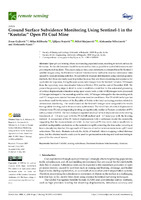
Ground surface subsidence monitoring using sentinel-1 in the “Kostolac” open pit coal mine
Zoran Gojković, Milan Kilibarda, Ljiljana Brajović, Miloš Marjanović, Aleksandar Milutinović, Aleksandar Ganić (2023)Open pit coal mining affects surrounding populated areas, resulting in terrain surface deformation. Surface deformation should be monitored as often as possible to control deformations and prevent potential incidents. This paper analyzes time series deformation estimated from the Sentinel-1 satellite images using the Persistent Scatterer Interferometry method to monitor subsidence rates caused by open pit mining activities. It is possible to measure deformations using classical geodetic methods, but those are rarely used in practice because they are time-consuming and ...Zoran Gojković, Milan Kilibarda, Ljiljana Brajović, Miloš Marjanović, Aleksandar Milutinović, Aleksandar Ganić. "Ground surface subsidence monitoring using sentinel-1 in the “Kostolac” open pit coal mine" in Remote Sensing (2023). https://doi.org/10.3390/rs15102519