Претрага
227 items
-

Paleomagnetic evidence for post-collisional Miocene clockwise rotation in the Serbian segment of the Vardar Zone and the Danubicum
Vesna Lesić, Emő Márton, Vesna Cvetkov, Dragana Tomić. "Paleomagnetic evidence for post-collisional Miocene clockwise rotation in the Serbian segment of the Vardar Zone and the Danubicum" in 26th IUGG General Assembly Prague, Czech Republic, International Union of Geodesy and Geophysics (2015)
-
Definisanje parametara čvrstoće na smicanje kod izvođenja kosina u ispucalom stenskom masivu
Zoran M. Berisavljević (2016-04-01)Definisanje parametara čvrstoće na smicanje ispucalih stenskih masa predstavlja jedanod najzahtevnijih zadataka mehanike stena. Geotehnička istraživanja su uglavnomograničena na rezultate laboratorijskih ispitivanja malih makroskopski homogenihuzoraka, sa kojih se vrši ekstrapolacija rezultata na terensku razmeru. Ispitivanja semogu vršiti in situ, ali su i ona ograničena veličinom korišćene aparature imikrolokacijom na kojoj se vrše ispitivanja. Pored toga, moguće je vršiti različitaispitivanja na fizičkim modelima, koja su veoma složena i skupa. Ekstrapolacijapodataka sa malog uzorka na terensku razmeru daje mnogo bolje rezultate ...naponsko stanje, ispucalost, heterogenost, čvrstoća na smicanje, geološki indeksčvrstoće, Hoek-Brownov materijal, kompozitni uzorci, dezintegracija, povratna analizaZoran M. Berisavljević. "Definisanje parametara čvrstoće na smicanje kod izvođenja kosina u ispucalom stenskom masivu" in Универзитет у Београду, Универзитет у Београду, Рударско-геолошки факултет (2016-04-01)
-
Regionalna karakterizacija karstnih podzemnih voda dela centralnog Balkana u funkciji njihovog održivog korišćenja i menadžmenta
Veljko J. Marinović (2022)Karstne podzemne vode koristi oko 700 miliona ljudi na svetu, čime je njihov značaj za svetsko stanovništvo nemerljiv. U sklopu doktorske disertacije vršena su istraživanja i analize karstnih sistema dela centralnog Balkana (Srbije, Crne Gore i Savskog sliva Bosne i Hercegovine), kako bi se evaluirao ovaj dragoceni resurs. Analize su vršene na primerima karstnih sistema vrela Perućac, Seljašnica, Mokra i Mlava (Srbija), Oko Bijele i Rijeka Crnojevića (Crna Gora) i vrelo Bosne (Bosna i Hercegovina), kao i na regionalnom ...karstni sistem, podzemna voda, pritisci na kvantitet i kvalitet, menadžment podzemnih vodnih resursaVeljko J. Marinović. Regionalna karakterizacija karstnih podzemnih voda dela centralnog Balkana u funkciji njihovog održivog korišćenja i menadžmenta, Beograd : [V. Marinović], 2022
-
Determination of the groundwater-leakage mechanism (binary mixing) in a karstic dam site using thermometry and isotope approach (HPP Visegrad, Bosnia, and Herzegovina)
Earth-Surface Processes,Geology, Pollution, Soil Science, Water Science and Technology, Environmental Chemistry, Global and Planetary ChangeLjiljana Vasić, Saša Milanović, Anita Puskás-Preszner, Laszlo Palcsu. "Determination of the groundwater-leakage mechanism (binary mixing) in a karstic dam site using thermometry and isotope approach (HPP Visegrad, Bosnia, and Herzegovina)" in Environmental Earth Sciences, Springer Science and Business Media LLC (2020). https://doi.org/10.1007/s12665-020-08910-x
-
Heavy metals in lignite and soil of Kostolac-Kovin coal basin, eastern Serbia - comparative analysis with selected cities in Serbia, region, Europe and world
Bogoljub Vučković, Bojan Dimitrijević (2023)The Kostolac-Kovin coal basin with an area of 320 km2, with 5 separate layers of coal and with a total of about 5.7 Bt of geological resources and reserves represents an exceptional potential for coal production in Serbia. The coal resources listed in this way are not fully exploitable, but they represent potential for consideration. In this paper, we deal with the geochemical characteristics of coal seams and perform a comparative analysis of coal affectation on the environment. With ...... (black dots) for the period 1941-2022. years in the Kostolac-Kovin coal-bearing basin, blue thick line — river Danube, blue thin line left – river Pelika Morava, blue thin line center — river Mlava, gray circle - uhderwater mining of Kovin lignite 178 4964000-| |j 4984000. 4962000— || 4960000—| ...Bogoljub Vučković, Bojan Dimitrijević. "Heavy metals in lignite and soil of Kostolac-Kovin coal basin, eastern Serbia - comparative analysis with selected cities in Serbia, region, Europe and world" in 9th International Conference Mining and Environmental Protection, 24–27. May 2023, Sokobanja, Beograd : Univerzitet u Beogradu, Rudarsko-geološki fakultet (2023)
-
Clockwise rotation in the Serbian segment of the Vardar zone and in the Danubicum of Eastern Serbia - tetonic implication
Vesna Lesić, Emo Marton, Vesna Cvetkov, Dragana Tomić. "Clockwise rotation in the Serbian segment of the Vardar zone and in the Danubicum of Eastern Serbia - tetonic implication" in 5. Hrvatski geološki kongres. Abstract Book 5th Croatian Geological Congress, Hrvatski geološki institut (2015)
-
Determining the Groundwater Balance and Radius of Influence Using Hydrodynamic Modeling: the Case Study of the Groundwater Source “Šumice” (Kikinda, Serbia)
A groundwater flow model was developed to simulate groundwater extraction from the public water supply source of the City of Kikinda. The hydrodynamic model includes the municipal groundwater source of Kikinda (Šumice and the Jezero Well), but also an extended area where there are groundwater sources that provide water supply to three factories: (MSK, TM and LŽT - Kikinda). Hydrodynamic modeling, based on the numerical method of finite differences will show the groundwater balance of the sources in the ...... infiltration of precipitation and surface water, since there is a good hydraulic contact between the aquifer and the river. The aquifer is drained naturally, at times of low river stages when groundwater flow is directed towards rivers, and artificially - through drilled and dug wells. The confined ...
... abandoned channel facies, floodplain facies, bog sediments, alluvia, and the youngest unit deposited since the Holocene – the beach facies of the Tisa River. Sedimentological analyses have shown that they were mostly made up of alevrites, sand, gravel and loess. HYDROGEOLOGICAL OVERVIEW A large number ...
... southwestern part of the area, where the depth of the layers which from the aquifer is relatively small and allows a hydraulic contact between the river and the aquifer over the alluvial layers. The main types of aquifer drainage are: artificial drainage (through groundwater extraction) and leakage ...Dušan Polomčić, Dragoljub Bajić, Jelena Zarić. "Determining the Groundwater Balance and Radius of Influence Using Hydrodynamic Modeling: the Case Study of the Groundwater Source “Šumice” (Kikinda, Serbia)" in Journal of Sustainable Development of Energy, Water and Environment Systems (2015). https://doi.org/10.13044/j.sdewes.2015.03.0017
-
Long-term rockslope monitoring and rockfall prediction
Miloš Marjanović, Biljana Abolmasov, Marko Pejić, Jelka Krušić. "Long-term rockslope monitoring and rockfall prediction" in Proceedings of 3rd European Regional Conference of IAEG/ Athens/ Greece/ 6-10 October 2021, International Association for Engineering Geology and the Environment (2021)
-
Regional Slope Stability Analysis in Landslide Hazard Assessment Context, North Macedonia Example
Miloš Marjanović, Biljana Abolmasov, Igor Peshevski, James Reeves, Irena Georgievska. "Regional Slope Stability Analysis in Landslide Hazard Assessment Context, North Macedonia Example" in Understanding and Reducing Landslide Disaster Risk, Springer International Publishing (2020). https://doi.org/10.1007/978-3-030-60227-7_29
-
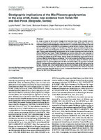
Stratigraphic implications of the Mio-Pliocene geodynamics in the area of Mt. Avala: new evidence from Torlak Hill and Beli Potok (Belgrade, Serbia)
Mt. Avala is located on the southern margin of the Pannonian basin (SPB), a border zone between the uplifted morphostructures of the Dinarides and Carpathian-Balkanides. Similar to the Pannonian basin, tectonostratigraphic evolution of the Mt. Avala area during the last 23 Ma has is characterized by syn- and post-rifting processes as well as tectonic inversion. Here, we present the results of field investigations of the Miocene‒Pliocene dynamics that led to different spatial positions of the same stratigraphic units (e.g. ...... (Continental-lacustrine) Bučvar clastites In the upper portion of the Bučvar Stream (Bučvar Potok), the left tributary of the Zavojnička Reka River, i.e. Bolečica River, a Figure 2. Schematic geological column of the pre-Neogene basement rocks and Neogene-Quaternary succession with palaeoenvironments and ...
... time, Torlak Hill and Mt. Avala represent a drainage divide be- cause the Topčiderska Reka water course flows to the Sava River whereas the Zavojnička Reka runs to the Danube River. At many locations, secondary E–NE directed streams have Figure 16. The digital elevation model (DEM) of the studied area ...
... al., 2007; KOVACS et al., 2015 and references therein). Based on these relief data as well as the observed Topčiderska Reka and Zavojnička Reka river flows that are obviously struc- turally controlled (see Figs. 1, 17 and 21), it is reasonable to ar- gue that drainage system and landscape evolution ...Ljupko Rundić, Meri Ganić, Slobodan Knežević, Dejan Radivojević, Miloš Radonjić. "Stratigraphic implications of the Mio-Pliocene geodynamics in the area of Mt. Avala: new evidence from Torlak Hill and Beli Potok (Belgrade, Serbia)" in Geologia Croatica (2019). https://doi.org/10.4154/gc.2019.11
-
Replica of the “Great Triangle Gold Nugget” Belonging to Belgrade University Collection, Gilded or Not?
... internal standards. Historic background The gold nugget was mined in the Southern Ural, in the gold-bearing sands of the Tachkou-Targanka river in 1842. At the time of its invention, the whole area of Zlatoust was the most significant in the world with its gold mines (JONES, 1844). Today ...Alena Zdravković, Maja Milošević, Ivana Jelić. "Replica of the “Great Triangle Gold Nugget” Belonging to Belgrade University Collection, Gilded or Not?" in 8th Mineral Sciences in the Carpathians Conference, Acta Mineralogica-Petrographica, Miskolc, Hungary, Department of Mineralogy, Geochemistry and Petrology, University of Szeged, Szeged, Hungary (2021)
-
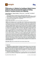
Application of a Method for Intelligent Multi-Criteria Analysis of the Environmental Impact of Tailing Ponds in Northern Kosovo and Metohija
Gordana Milentijević, Blagoje Nedeljković, Milena Lekić, Zoran Nikić, Ivica Ristović, Jelena Đokić (2016)... collectors was placed there when the landfill was constructed, releasing waste into the Ibar River. The tailings are still not managed properly [11]. Flotation landfill Gornje Polje (Figure 2a) is placed on the Ibar River bank, on the part of the terrain between Kosovska Mitrovica and Zvečan. On this landfill ...
... shows permanent toxic pollution of water and agricultural land [13]. All atmospheric water and waters from tailing ponds are released into the Ibar River through drainage systems in the tailings. The water bodies from the area as well as those from remote areas are highly endangered by the Energies ...
... tailing pond Žarkov Potok is an active landfill site only 2 km northeast from Kosovska Mitrovica, in the basin of Žarkov Potok, right next to the Ibar River. It was formed in 1975 and contains tailings from flotation Prvi Tunel. The space for deposition was constructed by building a dam 87 m high and with ...Gordana Milentijević, Blagoje Nedeljković, Milena Lekić, Zoran Nikić, Ivica Ristović, Jelena Đokić. "Application of a Method for Intelligent Multi-Criteria Analysis of the Environmental Impact of Tailing Ponds in Northern Kosovo and Metohija" in Energies, MDPI AG (2016). https://doi.org/10.3390/en9110935
-
Paleomagnetic study of Jurassic-Early Cretaceus sediments in the Danibicum of Eastern Serbia
... Arjana, Coşuştea, Upper and Lower Danubian thrust complexes. Our area of investigation belongs to the Upper Danubian on the Serbian side of the River Danube, but, it has a continuation in Romania, where it was studied earlier for paleomagnetism. The aim of our study was to find out if the study ...Vesna Cvetkov, Emo Marton, Vesna Lesić, Dragana Tomić. "Paleomagnetic study of Jurassic-Early Cretaceus sediments in the Danibicum of Eastern Serbia" in I Kongres geologa u Bosni i Hercegovini sa međunarodnim učešćem, Udruženje geologa u Bosni i Hercegovini (2015)
-
An arid phase in the Internal Dinarides during the early to middle Miocene: Inferences from Mg-clays in the Pranjani Basin (Serbia)
N. Andrić-Tomašević, V. Simić, O. Mandic, D. Životić, M. Suárez, E. García-Romero. "An arid phase in the Internal Dinarides during the early to middle Miocene: Inferences from Mg-clays in the Pranjani Basin (Serbia)" in Palaeogeography, Palaeoclimatology, Palaeoecology, Elsevier BV (2020). https://doi.org/10.1016/j.palaeo.2020.110145
-
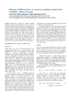
Influence of DEM resolution on numerical modelling of debris flows in RAMMS - Selanac case study
Debris flows induced by intensive rainfall represent very hazardous phenomena in many parts of the World. Methods for prediction of runout distance of flow like mass movements are different and depending on the input data, rheology, and available or appropriate numerical solution. However, sometimes it is not easy to obtain pre event and post event high-resolution data in the rural or mountainous area. Thus, the topology of terrain is the most important input parameter for the every real case ...... 11 and ξ=500 m/s2 (Fig 6). In both cases, there are a lot of outflow materials, since material was transported further throw valley of Selanacka river. This is something that would be interesting to include in future in modelling as an affect. By now we compared only amount of estimated volume. ...
... material were stopped in deposited area, and drained water was transported further with torrential flow which also made instabilities in the Selanačka river valley. Generally it is necessary for further research to testing model with influence of the torrential flood on the deposition zone in the same ...Jelka Krušić, Biljana Abolmasov, Mileva Samardžić Petrović. "Influence of DEM resolution on numerical modelling of debris flows in RAMMS - Selanac case study" in 4th Regional Symposium on Landslides in the Adriatic Balkan Region, 23-25 October 2019, Sarajevo, Bosnia and Herzegovina, Geotechnical Society of Bosnia and Herzegovina (2019). https://doi.org/ 10.35123/ReSyLAB_2019
-
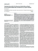
Hyperpycnites within the Devonian-Carboniferous flysch of the Carpatho-Balkanides (Kostadinovica, eastern Serbia)
Miloš Radonjić (2020)This study presents new discoveries of vascular plants and the trace fossil Dictyodora liebeana (GEINITZ) from the Devonian–Carboniferous Kučaj-Zvonce flysch of the Carpatho-Balkanides and the implications of this fossil association for its sedimentary setting. The occurrence of the described plant debris in a deep-marine environment indicates the presence of hyperpycnites within the siliciclastic turbidites exposed at the Kostadinovica locality. The sedimentological data and the characteristics of the fossil material support the proposed model in which the sediment was at ...Mississippian flora, Dictyodora liebeana (GEINITZ), hyperpycnites, Kučaj-Zvonce flysch, Carpatho-Balkanides... under hyperpycnal flows is discussed as an additional point to the overall interpretation of the system. As the hyperpycnal flows oc- cur during high river discharge into the basin they represent an efficient mechanism of transfer of clastic material from continen- tal environments to the deep-marine ...
... ion of hyperpycnites and their genetic model The sustained hyperpycnal flows which enter the basin last rela- tively long if the sediment-laden river discharge is sufficient to maintain the water density difference, usually for several days (MULDER & SYVITSKI, 1995). In contrast, remobilization ...
... intervals followed by upward fining intervals and intra-sequence erosional contacts (MULDER et al., 2003), all of which is a result of fluctuating river discharge; (2) the turbidites are represented by upward fining Bouma sequences (BOUMA, 1962) originating from a single, sediment-laden turbulent ...Miloš Radonjić. "Hyperpycnites within the Devonian-Carboniferous flysch of the Carpatho-Balkanides (Kostadinovica, eastern Serbia)" in Geologia Croatica, Croatian Geological Survey (2020). https://doi.org/10.4154/gc.2020.13
-
Machine learning based landslide assessment of the Belgrade metropolitan area: Pixel resolution effects and a cross-scaling concept
Improvements of Machine Learning-based landslide prediction models can be made by optimizing scale, customizing training samples to provide sets with the best examples, feature selection, etc. Herein, a novel approach, named Cross-Scaling, is proposed that includes the mixing of training and testing set resolutions. Hypothetically, training on a coarser resolution dataset and testing the model on a finer resolution should help the algorithm to better generalize ambiguous examples of landslide classes and yield fewer over/underestimations in the model. This ...Uroš Đurić, Miloš Marjanović, Zoran Radić, Biljana Abolmasov. " Machine learning based landslide assessment of the Belgrade metropolitan area: Pixel resolution effects and a cross-scaling concept" in Engineering Geology , Elsevier (2019). https://doi.org/10.1016/j.enggeo.2019.05.007
-
Hydrochemical changes and groundwater grouping data by multivariate statistical methods within one karst system: recharge–discharge zone (Eastern Serbia case study)
Ljiljana Vasić, Dragana Živojinović, Vladana Rajaković-Ognjanović. "Hydrochemical changes and groundwater grouping data by multivariate statistical methods within one karst system: recharge–discharge zone (Eastern Serbia case study)" in Carbonates and Evaporites, Springer Science and Business Media LLC (2020). https://doi.org/10.1007/s13146-019-00548-6
-
Prvi nalazi repatih vodozemaca (Urodela) u pleistocenskoj pećinskoj fauni Srbije; još jedna kockica u slagalici
Fosilna fauna pleistocenskih pećina odslikava sastav faune njihove okoline. Najčešće se u njima naleze ostaci krupnih sisara ledenog doba koji su je koristili kao stanište. Uz njih česti su i ostaci drugih sitnih kičmenjaka kao što su sitni sisari, ribe, vodozemci, gmizavci i ptice. Ostaci sitnih kičmenjaka u većini slučajeva u pećinu dospevaju kao plen grabljivica (ptice i sisari) ali je manji broj njih pećinu koristio i kao sklonište ili stanište. U proučavanje fluktuacija pleistocenske klime sve češće se ...... found in three caves in Serbia. The Smolućka Cave is located the southwest of Serbia, about 15 km northeast of Tutin in the canyon of the Smolućka River. In it, 18 vertebrae were found, which were identified as Sa/amandra salamandra. Unfortunately, these data are available to us only from the literature ...
... black background. The appearance of salamander remains indicates that the cave was most likely surrounded by dense forest. The proximity of the river provided a safe environment for the development of tadpoles. Due to its toxicity, it is most likely that the remains of the salamander did not enter ...Dragana Đurić, Katarina Bogićević, Draženko Nenadić, Mihajlo Jovanović, Aleksandra Savković. "Prvi nalazi repatih vodozemaca (Urodela) u pleistocenskoj pećinskoj fauni Srbije; još jedna kockica u slagalici" in Zbornik sažetaka III Kongresa geologa Bosne i Hercegovine sa međunarodnim učešćem. Neum, 21.-23. septembar/rujan 2023, Ilidža : Udruženje geologa Bosne i Hercegovine (2023)
-
Tectonothermal evolution of an asymmetric extensional system: the Juhor Mts in Central Serbia (Northern Serbomacedonian massif)
Miloš Radonjić, Uroš Stojadinović, Elco Luijendijk, Dejan Radivojević, Željko Golubović, Nikola Vuković (2018)... ene to Quaternary sediments of the southernmost Pannonian Basin. The Juhor Mts, together with other uplifted areas along the Morava river corridor, such as Crni Vrh, Mojsinjske Mts, Poslonske Mts, comprise part of northern Serbomacedonian Massif. The Serbomacedonian Massif ...Miloš Radonjić, Uroš Stojadinović, Elco Luijendijk, Dejan Radivojević, Željko Golubović, Nikola Vuković. "Tectonothermal evolution of an asymmetric extensional system: the Juhor Mts in Central Serbia (Northern Serbomacedonian massif)" in 17th Serbian Geological Congress, Vrnjačka Banja, 17-20 maj 2018, Srpsko geološko društvo (2018)