Претрага
274 items
-
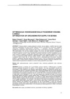
Optimizacija vodosnabdevanja podzemnim vodama u Srbiji
Dušan Polomčić, Zoran Stevanović, Petar Dokmanović, Vesna Ristić-Vakanjac, Bojan Hajdin, Saša Milanović, Dragoljub Bajić (2012)... accumulated in thick Quaternary and Neogene water-bearing deposits of intergranular porosity and in mountain ranges built up of karstified carbonate rocks. Serbian groundwater has not yet been thoroughly investigated in spite of its intensive usage (it is used by approximately 75% of the population). ...
... accumulated in thick Quaternary and Neogene water-bearing deposits of intergranular porosity and in mountain ranges built up of karstified carbonate rocks. Serbian groundwater has not yet been thoroughly investigated in spite of its intensive usage (it is used by approximately 75% of the population). Based ...Dušan Polomčić, Zoran Stevanović, Petar Dokmanović, Vesna Ristić-Vakanjac, Bojan Hajdin, Saša Milanović, Dragoljub Bajić. "Optimizacija vodosnabdevanja podzemnim vodama u Srbiji" in Zbornik radova XIV srpskog simpozijuma o hidrogeologiji sa međunarodnim učešćem, Zlatibor, 17-20. maj 2012. godine , Beograd : Rudarsko-geološki fakultet (2012)
-
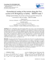
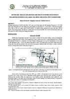
Geotechnical zoning of the terrain along the first section of E-80 highway in Serbia – SEETO route 7
Part of E-80 highway that passes through Serbia (from the city of Nis to the administrative border Merdare) is 77 km long. The highway is divided into two sections: the first from Nis to Plocnik (39.4 km long) and the second from Plocnik to the administrative border with Kosovo. The route is designed through a typical plain and hilly terrain in which different geological units are dominant: crystalline schists, neogene sediments of foothills and quaternary sediments in the valley ...... engineering geological characteristics (conditionally stable on slopes). These terrains include crystalline schist complex and clastic carbonate rocks with eluvial-deluvial weathering zone of thickness over 2 m on slopes with inclination >100, lake sediments with eluvium and deluvium >2 m on ...
... erosion as well as shallow sliding on unsecured slopes over 2 m in height. Heterogeneity in terms of lithological composition, weathering degree of rocks as well as variable physical- mechanical properties, does not have significant impact on conditions of construction. Category B includes terrains ...Dragoslav Rakić, Zoran Berisavljević, Irena Basarić, Snežana Bogdanović, Jovana Janković. "Geotechnical zoning of the terrain along the first section of E-80 highway in Serbia – SEETO route 7" in Proceedings of the XVII European Conference of Soil Mechanics and Geotechnical Engineering ECSMGE-2019, Reykjavik, Iceland, 1-6. 09. 2019., ISSMGE, ECSMGE-2019 (2019). https://doi.org/10.32075/17ECSMGE-2019-0393
-

Regional Slope Stability Analysis in Landslide Hazard Assessment Context, North Macedonia Example
Miloš Marjanović, Biljana Abolmasov, Igor Peshevski, James Reeves, Irena Georgievska. "Regional Slope Stability Analysis in Landslide Hazard Assessment Context, North Macedonia Example" in Understanding and Reducing Landslide Disaster Risk, Springer International Publishing (2020). https://doi.org/10.1007/978-3-030-60227-7_29
-
Грешка инклинације код депозиционе реманетне магнетизације
Mirko Petković, Vesna Cvetkov (2019)... factor. This procedure gives reliable results if the carrier of the remanent magnetization is magnetite, which is most common in sedimentary rocks. If the carrier of remanent magnetization is hematite, goethite or pyrrhotite, the shown approximation cannot be applied due to the specificity ...
... 111, 465-469. 7. Kodoma, K., (2009): Simplification of the anisotropy-based inclination correction technique for magnetite and hematite-bearing rocks: a case study for the Carboniferous Glenshaw and Mauch Chunk Formations, North America, Geophysical Journal International 176, 467–477. 8. Miličić ...Mirko Petković, Vesna Cvetkov. "Грешка инклинације код депозиционе реманетне магнетизације" in II Когрес геолога Босне и Херцеговине са међународним учешћем , Удружење геолога у Босни и Херцеговини (2019)
-

Хазард од клизишта у Србији у 21. веку
Biljana Abolmasov (2019)... scientific researc the type of movement more common types are slides, flows and falls. type of material involved there are all types of material: rocks, de Landslides can be caused by one or more factors of which mo geological and engineering geological are main causal factors. G terrain characteristics ...
... published scientific resear the type of movement more common types are slides, flows and falls type of material involved there are all types of material: rocks, Landslides can be caused by one or more factors of which m geological and engineering geological are main causal factors. | terrain characteristics ...Biljana Abolmasov. "Хазард од клизишта у Србији у 21. веку" in Геохазард у Србији у 21. веку – знање је најбољи бедем против стихије, Српска академија наука и уметности (2019)
-
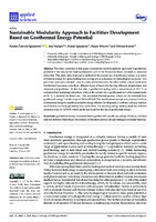
Sustainable Modularity Approach to Facilities Development Based on Geothermal Energy Potential
The study presented in this paper assessed the multidisciplinary approach of geothermal potential in the area of the most southeastern part of the Pannonian basin, focused on resources utilization. This study aims to present a method for the cascade use of geothermal energy as a source of thermal energy for space heating and cooling and as a resource for balneological purposes. Two particular sites were selected—one in a natural environment; the other within a small settlement. Geothermal resources come ...геотермална енергија, Панонски басен, геотермална каскада, енергетска ефикасност, бањски центри, балнеологија, биоклиматска архитектура, стратегије пасивног дизајнирања, модуларни објекти... it takes place along fault-line structures and at the contact point of water-permeable and water-resistant rocks. The outlet temperatures of geothermal waters formed within this type of reservoir in the vicinity of Fruska Gora vary from 15 to 60 ◦C. At the study site, geothermal resources were formed ...
... genetic parameters, geothermal water on the Ljuba site belong to the carbonated type, and this confirmed that the primary geothermal reservoir was formed in the Triassic rocks of the basin bedrock (Figure 9). Appl. Sci. 2021, 11, 2691 13 of 24 Table 5. Physical-chemical features of geothermal waters ...
... The geothermal source is in the form of a spring, which is very rare for the basins. The reservoir is formed within Triassic limestone, and the water belongs to the HCO3–Ca type as expected with this kind of reservoir. The uniqueness of this geothermal water may be seen from the chemical- specific composition ...Nataša Čuković-Ignjatović, Ana Vranješ, Dušan Ignjatović, Dejan Milenić, Olivera Krunić. "Sustainable Modularity Approach to Facilities Development Based on Geothermal Energy Potential" in Applied Sciences-Basel, МDPI (2021). https://doi.org/10.3390/app11062691
-
Early–Middle Jurassic brachiopods from Ponor Mountain, Western Balkan Mountains, Bulgaria; taxonomy, biostratigraphy and occurrence in the context of the early Toarcian Oceanic Anoxic Event
Barbara V. Radulović, Lubomir S. Metodiev, Neda Motchurova-Dekova, Platon Tchoumatchenco. "Early–Middle Jurassic brachiopods from Ponor Mountain, Western Balkan Mountains, Bulgaria; taxonomy, biostratigraphy and occurrence in the context of the early Toarcian Oceanic Anoxic Event" in Historical Biology (2023). https://doi.org/10.1080/08912963.2023.2190757
-
BEYOND 2020 - Geology explorations and open pit activities affectation in reclamation designing in Kolubara Coal Mines (KCM) Serbia, new considerations
Geology explorations in KCM runs from 1936. year up to these days and still ongoing. Results in >7,200 drill holes with ≈600,000 m of core drilling and gave lignite ore resources of > 4,1Bt, which 1,15Bt are excavated since 1986. of XIX up to early years of XXI century. For further mining operations in open pits stay 1,5Bt of lignite. Under waste heaps are ≈80 km2, additional 85 km2 should be filled. All of that masses/areas were, are ...Bojan Dimitrijević, Bogoljub Vučković, Radmila Gaćina. "BEYOND 2020 - Geology explorations and open pit activities affectation in reclamation designing in Kolubara Coal Mines (KCM) Serbia, new considerations" in 17th International Conference of the open and underwater mining of minerals, Sts. Constantine and Helena Resort, Varna, 18-22 September, Bulgaria, Sofia, Bulgaria : Scientific and Technical Union of Mining, Geology and Metallurgy, (2023)
-
Srbija u OneGeology Europe
Геолошки завод Србије као носилац Пројекта ОneGeologyEurope заједно са Рударско геолошким факултетом и Министарством за природне ресурсе, рударство и просторно планирање су се укључили у међународни Пројекат OneGeology Europe у мају 2013. године у већ поодмаклој фази израде Пројекта. До краја 2013. године испунили су завршене активности које треба да доведу до пуноправног укључења у Пројекат чиме је Република Србија нашла своје место на Геолошкој карти Европе 1:1М. Геолошка карта Србије 1:1М представља компилациону односно поједностављену верзију ОГК 1:500 ...... project participants. Through the activities of earlier initiatives, 1G-E made a geological vocabulary that describes the lithology, age and genesis of rocks and tectonic structures. This document provides descriptions of geological vocabulary, concepts, definitions of concepts and their mutual relations ...
... project participants. Through the activities of earlier initiatives, 1G-E made a geological vocabulary that describes the lithology, age and genesis of rocks and tectonic structures. This document provides descriptions of geological vocabulary, concepts, definitions of concepts and their mutual relations ...
... deposits (Crane Ea (2112 geld FB daily 4 Latte+trach 9 Pliocene __Trachybasalts, trachytes and leucites; a-pyroclasttes piroklasit Plocene BB oranic rocks alte +trachytic 112232tlqupt3 [ps |2234 40 Pliocene __Quarizaites and trachiandesites; a-pyroclasites Kvaclatit i trahiandezi,a-piroklast rock+pyroctastic ...Danka Blagojević, Ranka Stanković, Petar Stejić, Velizar Nikolić. "Srbija u OneGeology Europe" in Zapisnici Srpskog geološkog društva za 2013. godinu, Beograd : Srpsko geološko društvo (2014)
-
Soil oscillation law parameter determination with the application of Lagrange’s theorem at “Kovilovača“ open pit
... 20 to 0.80 m, the direction of propagation is NE-SW and a slope of about 42º towards the southwest. These rocks, in engineering and geological terms, belong to a group of associated rocks, which are cracked and carstified [7]. During previous exploitation and exploitation works, no significant ...
... deformations, which would significantly influence the process of exploration and exploitation, were noted in the deposit. Only after blasting, blocks of rocks 0.50 m3 occur, which could be attributed to the effect of small faults and carstified cracks in the de- posit. By examination the physical and me- ...Suzana Lutovac, Nebojša Vidanović, Čedomir Beljić, Zoran Gligorić. "Soil oscillation law parameter determination with the application of Lagrange’s theorem at “Kovilovača“ open pit" in Mining and Metallurgy Engineering Bor, Bor : Mining and Metallurgy Institute Bor (2015). https://doi.org/10.5937/MMEB1503053L
-
Еоценска фауна југозападног дела Сирт басена (Либија)
Љупко Рундић, Мери Ганић (2020)Љупко Рундић, Мери Ганић. "Еоценска фауна југозападног дела Сирт басена (Либија)" in Записници Српског геолошког друштва, Српско геолошко друштво (2020)
-
Novi pristup proučavanju tekstura minerala značajnih za istraživanje rudnih ležišta
Aleksandar Pačevski (2022)... possibilities and efficiency of their exploitation. With the development of polarized light microscopy as the basic methods of minerals, ores and rocks study, numerous textural relationships of minerals have been determined and clearly defined, such as exsolutions, replacements, etc, which have ...Aleksandar Pačevski. "Novi pristup proučavanju tekstura minerala značajnih za istraživanje rudnih ležišta" in 18. Kongres geologa Srbije “Geologija rešava probleme” Divčibare, 01-04 jun 2022., Beograd : Srpsko geološko društvo (2022)
-
Preliminary regional landslide susceptibility assessment using limited data
Igor Peshevski, Milorad Jovanovski, Biljana Abolmasov, Jovan Papic, Uroš Đurić, Miloš Marjanović, Ubydul Haque, Natasha Nedelkovska (2019)In this paper a heuristic approach for preliminary regional landslide susceptibility assessment using limited amount of data is presented. It is called arbitrary polynomial method and takes into account 5 landslide conditioning parameters: lithology, slope inclination, average annual rainfall, land use and maximum expected seismic intensity. According to the method, in the first stage, a gradation is performed for each of the carefully selected conditioning parameters by assigning so called rating points to the grid cells on which the ...... granites, diorites, rhyolites, ser- pentinites, gabbros, diabases etc. The Palaeozoic is represented by a thick complex of metamorphic rocks, rarely igneous rocks. The rocks from the Devonian age are the commonly occurring ones in the area, and here belong to the phyllitic schists, meta- conglomerates, ...
... schists and marbles. It is important to note that most landslides in the study area have been reported to occur at the contact of the weak schist type rocks and the soil debris which covers them. G eo lo g ia C ro a tica Peshevski et al.: Preliminary regional landslide susceptibility assessment ...Igor Peshevski, Milorad Jovanovski, Biljana Abolmasov, Jovan Papic, Uroš Đurić, Miloš Marjanović, Ubydul Haque, Natasha Nedelkovska. "Preliminary regional landslide susceptibility assessment using limited data" in Geologica Croatica , Croatian Geological Society (2019). https://doi.org/10.4154/gc.2019.03
-
Prostorni položaj ofiolita istočne Vardarske zone: geofizičko-geološki model i njegove geodinamičke implikacije
Dragana D. Petrović (2015-12-29)Centralni deo Balkanskog poluostrva je geotektonski veoma složen. Tetis je zatvorentokom gornjeg mezozoika, a ofioliti na zapadu i ofioliti Vardarske zone predstavljajuostatke nekadašnjih okeanskih prostora. Najistočniji deo Vardarske zone razlikuje se odsvih ostalih ofiolita na Balkanskom poluostrvu i karakteriše se najizraženijim suprasubdukcijskimafinitetom. Istočna vardarska zona locirana je u centralom delu Srbije.Na severu se prostire do Apusena u Rumuniji, a na jugu obuhvata cetralni deoMakedonije i Peonias zonu u severnoj Grčkoj. Istočna vardarska zona se nalazi istočnood geotektonske jedinice Kopaonik ...... Tectonic setting of basic volcanic rocks determined using trace element analyses. Earth Planet. Sci. Lett., 19 (2), 290–300. Pearce, J. A., Harris, N. B. W., Tindle, A. J., 1984. Trace element discrimination diagrams for the tectonic interpretation of granitic rocks. Journal of Petrology, 25, 956-83 ...
... and gravity data was performed. Mathematical transformations were applied on gravity and geomagnetic data in order to determine the position of rocks masses that caused the anomalies. The pattern of geomagnetic anomalies depend not only form dip angle of the source of the anomaly, but of remanent ...
... istorije ovog dela Evrope. 101 7. LITERATURA Anders, B., Reischmann, T., Poller, U., Kostopoulos, D., 2005. Age and origin of granitic rocks of the eastern Vardar Zone, Greece: new constraints on the evolution of the Internal Hellenides, Journal of the Geological Society, London 162 ...Dragana D. Petrović. "Prostorni položaj ofiolita istočne Vardarske zone: geofizičko-geološki model i njegove geodinamičke implikacije" in Универзитет у Београду, Универзитет у Београду, Рударско-геолошки факултет (2015-12-29)
-
Geološko-geofizički model dela Timočkog magmatskog kompleksa
Snežana M. Ignjatović (2014-06-30)Timočki magmatski kompleks (TMK) u geotektonskom smislu pripada KarpatoBalkanidimaistočne Srbije, koji su deo Tekijsko-Dakijske jedinice. TMK je nastaotokom kontinuirane vulkanske aktivnosti, koja je trajala oko deset miliona godina iodvijala se generalno u tri faze (Zimmerman et al., 2008, Kolb et al., 2013, Banješević,2006). Pomeranje vulkanskog fronta je išlo od istoka ka zapadu (von Quadt et al., 2002,2003, 2007). Ovaj kompleks pripada tetijskom evroazijskom metalogenetskom pojasu usvetu poznat po ležištima bakra i zlata (Janković, 1990).U doktorskoj disertaciji su prikazani rezultati ...Timočki magmatski kompleks, aeromagnetska istraživanja, gravimetrijskaistraživanja, 2D geološko-geofizički model, Valja Strž, magmatsko telo... Beograd http://www.northernminer.com/news/reservoir-freeport-hit-high-grade-copper-at timok/1001679498/ http://www.northernminer.com/news/reservoir-freeport-hit-high-grade-copper-at%20timok/1001679498/ http://www.northernminer.com/news/reservoir-freeport-hit-high-grade-copper-at%20timo ...
... geoloških istraţivanja poslednjih godina. Reservoir Minerals Inc i Freeport McMoRan objavili su rezultate o bušotini FMTC 1210, koji ukazuju na prisustvo porfirske bakar – zlato mineralizacije ispod Miocenskih sedimenata (http://www.northernminer.com/news/reservoir-freeport- hit-high-grade-copper-at ...
... podaci, geološki podaci i podaci dobijeni istraţnim bušenjem. http://www.northernminer.com/news/reservoir-freeport-hit-high-grade-copper-at%20timok/1001679498/ http://www.northernminer.com/news/reservoir-freeport-hit-high-grade-copper-at%20timok/1001679498/ Geološko-geofizički model dela Timočkog ...Snežana M. Ignjatović. "Geološko-geofizički model dela Timočkog magmatskog kompleksa" in Универзитет у Београду, Универзитет у Београду, Рударско-геолошки факултет (2014-06-30)
-

Еволуција напонског поља подручја Интерних Динарида у Србији током алпске орогенезе
Ana S. Mladenović (2015-06-19)Циљ ове докторске дисертације био је реконструкција еволуције напонског пољаЗемљине коре у подручју Интерних Динарида у Србији током Алпске орогенезе.Истраживања за потребе решавања овог проблема су изведена у два дела. Првидео обухватао је анализу палеонапона на дефинисаном подручју истраживања,док се други део односио на анализу тренутно активног поља напона у овом делуБалканског полуострва. Истраживано подручје обухвата унутрашњи деоДинарског орогеног појаса, који се простире у централној и западној Србији. Собзиром на циљ истраживања, истраживано подручје је дефинисано тако даобухвата три ...Интерни Динариди, анализа палеонапона, фокални механизмиземљотреса, напонско поље, тектоно-магматски догађаји... alterations in igneous rocks of Kopaonik region. Memoirs du service geol. et geof. XIX, 1 – 138. Belgrade Мићић И. 1988. Терцијарни вулканизам Рогозне. Записници Српског геолошког друштва за 1985/86: 315 – 318 Milovanović D. 1984. Petrology of low metamorphosed rocks of the central part of ...
... 87: 225 – 232 Pomella H. 2014. Magnetic fabric of brittle fault rocks. Geophysical Research Abstracts (EGU). 16: 12505 Prelević D., Akal C., Foley S.F., Romer R.L., Stracke A., Van Den Bogaard P. 2012. Ultrapotassic mafic rocks as geochemical proxies for post-collisional dynamics of orogenic ...
... to solve cross-cutting relationships of the faults and/or the slip sense indicators, and also to determine the relation of these structures to the rocks of known (stratigraphic or absolute) age. These data were later used to calculate the stress tensors which activated the considered faults. Relative ...Ana S. Mladenović. "Еволуција напонског поља подручја Интерних Динарида у Србији током алпске орогенезе" in Универзитет у Београду, Универзитет у Београду, Рударско-геолошки факултет (2015-06-19)
-
Refinement of waste phosphogypsum from Prahovo, Serbia: characterization and assessment of application in civil engineering
Josip Išek, Lazar Kaluđerović, Nikola Vuković, Maja Milošević, Ivana Vukašinović, Zorica Tomić (2020)... from natural radionuclides that are members of the ŠU and Th decay series. Sedimentary phosphate rocks contain high concentrations of uranium and low concentrations of thorium, while igneous rocks have lower concentrations of uranium and higher concentrations of thorium and rare earth elements ...Josip Išek, Lazar Kaluđerović, Nikola Vuković, Maja Milošević, Ivana Vukašinović, Zorica Tomić. "Refinement of waste phosphogypsum from Prahovo, Serbia: characterization and assessment of application in civil engineering" in Clay Minerals, Cambridge University press (2020). https://doi.org/10.1180/clm.2020.11
-
Damage quantification of built stone on Dark Gate (Belgrade, Serbia): sample of damage index application for decay rate evaluation
The Dark Gate is the monument of culture, part of the cultural and historical complex of the Belgrade Fortress. It is constructed of limestone blocks that after 270 years of exposure to environmental conditions and different anthropogenic influences show wide ranges of decay forms. During 2007, detail registration of all built limestone microfacies and weathering forms was done using tools of monument mapping. A correlation scheme ‘‘intensity– damage category’’ was made according to the type, intensity, and distribution of ...... carbonate rocks. Springer, Berlin, p 976 Folk R L (1959) Practical petrographical classification of limestones. Bulletin 43, American association of petroleum geologists, pp 1-38 Folk R L (1962) Spectral subdivision of limestone types. In: Ham W E (ed) Classification of carbonate rocks. AAPG ...
... microscopic microfacial analyses on built stone sam- ples reveal that three facies type of limestone were used for construction of the Dark Gate. The rocks are differentiated according to macroscopic visible component, fabric and @ Springer Environ Earth Sci (2015) 73:6181–6193 color, as well as ...Maja Franković, Nevenka Novaković, Vesna Matović. "Damage quantification of built stone on Dark Gate (Belgrade, Serbia): sample of damage index application for decay rate evaluation" in Environmental Earth Sciences, Springer Science and Business Media LLC (2015). https://doi.org/10.1007/s12665-014-3843-z
-
Characterization and Environmental Evaluation of Recycled Aggregates from Construction and Demolition Waste in Belgrade City Area (Serbia)
Filip Abramović, Miroslav Popović, Vladimir Simić, Vesna Matović, Radmila Šerović. "Characterization and Environmental Evaluation of Recycled Aggregates from Construction and Demolition Waste in Belgrade City Area (Serbia)" in Materials, MDPI AG (2024). https://doi.org/10.3390/ma17040820